You have made it to the Southernmost Point in the Continental United States! The massive, brightly painted buoy that marks the Southernmost Point sits on land and is visited and photographed more than most buoys. It has the ability to attract people from around the world around the clock. Just watch. Even if you are thousands of miles away, you can experience being here with us. The Southernmost Webcam brings you the sunrises, sunsets, sunshine and storms. See the revelers, the trolleys, and the occasional rooster making a cameo.
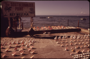 By Flip Schulke – U.S. National Archives and Records Administration, Public Domain, sourceA Concrete Icon With a Wooden Past. The buoy-shaped marker standing today was built by the City of Key West and unveiled on September 10, 1983, under Mayor Dennis Wardlow, replacing a much simpler wooden sign that had marked the spot since at least the late 1960s. That earlier sign read The Southernmost Point, of Southernmost City, Key West Fla., with a separate marker nearby noting the distance to Cuba. Local artist Danny Acosta designed the concrete replacement, which stands about 12 feet tall and 7 feet wide. Key West’s Public Works Department has kept it in shape ever since, repainting and refurbishing it periodically, including a repaint after Hurricane Irma in 2017.
Ninety Miles to Cuba. The marker’s famous claim of ninety miles to Cuba has been part of this spot’s identity since the wooden-sign era, and it is the reason so many visitors stop here rather than anywhere else in the Florida Keys. The actual distance is closer to ninety-four statute miles, but the ninety-mile claim has stuck for decades. Key West sits so far out in the Straits of Florida that Havana is closer than most Florida cities: this small island is nearer to the Caribbean than it is to Miami.
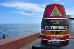 By Radomianin – Own work, CC BY-SA 4.0, sourceThe Southernmost Point in the Continental U.S. The corner of South and Whitehead Streets is famous as the southernmost point in the continental United States, and it is the southernmost spot the public can walk right up to. A few slivers of land farther south, including Ballast Key and portions of Fort Zachary Taylor and the old Truman Annex, sit slightly closer to the equator, but they are private or restricted rather than open to visitors. For everyone else, this is the end of the road, literally: the Overseas Highway and the whole stretch of the continental United States comes to a stop right here, ninety miles of open water short of Cuba.
Whatever brings you to the Southernmost Point, whether it is the photo, the history, or those ninety miles of ocean, the Southernmost Webcam keeps a live window on it day and night. See it for yourself, any time.